| CROSS COUNTRY II | |||
|
A walking tour from Canada to [Gulf of] Mexico 2005 PHOTOGRAPHS
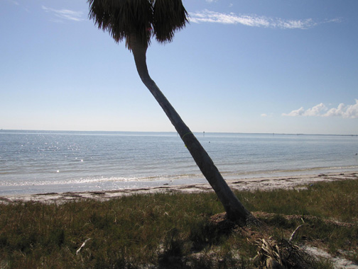
Week 18/19 Final tie off at Shell Beach 11/14/05 1:10PM EST. Enterprise, Alabama to Shell Beach, Florida November 7, 2005 to November 14, 2005 NEWS UPDATE Cross Country 2004 - 2005
I got to the Gulf of Mexico at Shell Point, Florida on Monday, November 14th, which was day number 128 of this second cross country walk. Since there was no international boundary to cross as in the three previous start/end points, I stopped walking at the water's edge. The trip totaled 2268 miles through ten states at an average just under 18 miles per day. Each day's walk began at first light, and after the opening week, I was able to maintain a pace of 3 mph, completing the day's mileage in six hours or less. The balance of the day was spent resting, recuperating, reading, sightseeing, and reviewing the day's photographs. As with last year's trip, I took something over two thousand images, posting a selected dozen or so on the website each week. The concept of this walk began simply enough, really, just as a visual pun on the phrase - "cross country". It evolved into a project that took more than nine months over the course of two years to literally walk cross country twice from international border to international border(or land's end). Cross Country I was a 1900 mile diagonal from Juarez,Mexico/El Paso, Texas to Sault Ste. Marie, Michigan/Sault Ste. Marie, Ontario,Canada. Cross Country II was the opposing diagonal beginning at the international boundary in Montana (above Opheim) with Canada's Saskatchewan Province, a coordinate due North of the Juarez walk of 2004 and ending on the Gulf of Mexico at a point due South of the Sault Ste. Marie terminus of 2004. These four coordinates: N. 31° 45'56.2"; W. 106° 27'11.3" (Juarez/El Paso May 19,2004) N. 46° 30' 08.4"; W. 84° 20'55.4" (Sault Ste.Marie September 18,2004) N. 48° 59' 58.9"; W. 106° 22'37.2" (Montana/Canada July 10,2005) N. 30° 03'15.5"; W. 84° 17'47.0" (Shell Pt., FL November 14, 2005) constitute a four thousand mile "X" over a map of the United States. They give new meaning to me of the phrase, "cross country" as well as a new understanding of the geography of a 20 state area of the US. This year's trip would not have been possible without the assistance of many people, but principally to my friend, Roscoe West, who was the driver of the support vehicle, our RV home/base camp for the trip; to Desiree Manville, who kept the studio operational and the website functional; to Alexandra Benjamin who gives me love, support, encouragement, and kept the home fires burning. To my friends who visited me along the way, my deepest appreciation for being there. To the many new acquaintances met along the road who offered help, a ride, conversation, or a place to get off the road, I offer my sincere thanks; you are the proof that we live in one of the special places of the world. Day 100 October 17, 2005 marked the 100th day of the second cross country walk. The day ended in Selmer, Tennessee less than twenty miles from the Mississippi border. Mississippi, Alabama, and Florida remain before reaching our destination at the Gulf of Mexico on the Florida panhandle. To date we’ve covered 1747 miles since leaving the border in Canada in July. At the pace of walking, the landscape is slow in changing, but the limitless fields of wheat in the north evolve to wheat and soybeans, to soybeans and corn, and then nothing but corn. By Missouri, soybeans reappear, and then come the timbered hills of the Mark Twain forest. Finally by the flood plains of the Mississippi, rice and cotton begin to appear. In western Tennessee cotton is the dominant crop. The towns we’ve passed through have been mostly small, the cities, rarely seen, are on the small side, too, as the route chosen has been primarily the county roads and state highways. The people have been curious and helpful - it is the rare day that no one stops to offer a ride or assistance; some days as many as six vehicles have stopped to help or just to chat about the trip. We have camped by the roadside, in city, state and one national park, commercial RV parks. We have been welcomed at people’s farms and ranches, their fields, even their backyards. Typically, we are up before sunrise, have some espresso and hot oatmeal before starting to walk, the dog and me, at first light. Cyrano does the first five miles before it gets too hot or there is too much traffic. After the initial week of getting the “kinks” out, it’s been possible to do the day’s eighteen miles in about six hours or less. The weather has been superb for the most part, tending to be warmer and drier than “normal”. In 100 days, it has rained only for portions of seven. The local forecasts which have been promising cooler fall temperatures usually elude us, though in October it has been in the 40's or low 50's in early morning, then rising by 35 to 45 degrees by early afternoon. I have seven pairs of shoes and boots(two are only used for rain) which I change daily. Blisters were gone after the first week, and until a bad shin splint in the last week, my health has been excellent. I’ve lost a lot of weight which has created one of the trips more pleasurable experiences: buying shorter belts and smaller pants. Even though this trip is longer than last years, I’ve been doing more miles each day, and barring some catastrophe, the trip should terminate at the Gulf by mid-November. Cross Country II Starting - one more time Roscoe West and I loaded up the RV support vehicle and left Taos on July 9th. We stopped in Denver for gas and supplies then drove up to Niwot, Colorado where we picked up an old friend of mine, Jim Beckley, who had agreed to walk the first hundred miles with me. We got as far as Buffalo, Wyoming that first night, camped there, and left early the next day to drive to the Canadian border with Montana at Opheim. We got to the international border crossing in the late afternoon of the 10th nearly 1200 miles from Taos. We walked to the border, took some photos, got a GPS fix, then began the walk south on Montana 24. We only did a couple of miles before making camp for the night on the edge of a field of peas. This trip is the second part of a journey begun in the summer of 2004 when I walked from the Juarez/El Paso border in Mexico to the US/Canada border at the locks of the Sault Ste. Marie in the upper penisula of Michigan where it meets Ontario. Our current starting point is due north of Juarez at 106 degrees, 24 minutes west longitude and the 49th parallel, the latitude of the western United States border. The terminus of the trip will be near Panacea, Florida on the Gulf of Mexico at 84 degrees 20 minutes west longitude - due south of Sault Ste. Marie. In short, I will have superimposed an "X" on the map of the United States. The 2004 trip was 1900 miles long. This year's version is longer- perhaps as long as 2300 miles. This in part because we started further north, and because there seem to be fewer roads with the preferred SE bearing of the destination in Florida causing us to take quite a few "doglegs". The first week was marked with temperatures in the high 90's, and some unexpectedly high winds gusting to 60-70 mph in one severe storm. Evenings were in the good sleeping 50?. Jim did most of his 100 miles then caught a ride in Plentywood, Montana to meet his son in Wyoming for his return trip to Colorado. Murphy's Law is never too far away: My trusty Canon that made it through the whole of last year's trip, failed on day 2, corrupting the files of all earlier photographs, so the photographs on Week 1 of the website are the work of Jim Beckley and Roscoe West. I'm grateful to them for letting me use them, and am thankful as well for their friendship and companionship on the trip. A new camera arrived yesterday in Williston, North Dakota, and I am already in the learning curve of trying to use it correctly. My bad technology karma continued yesterday when my cell phone died. We've seen deer and antelope, a dead badger, and lots of wildfowl- ducks, grouse, geese, pheasants, and were surprised to see two groups of American white pelican. The northern prairie landscape is a veritable sea of wheat punctuated with acreage of flax and mustard. We crossed the Montana/North Dakota border yesterday at 8:00 am and stopped in Williston for mail and supplies. Today we began the southern journey crossing the Missouri River on the Lewis and Clark Bridge. They passed through here in April of 1805. We will travel through the remainder of North Dakota, then on to South Dakota, Nebraska, Iowa, Missouri, Tennessee, Mississippi, Alabama to the Florida panhandle and the Gulf of Mexico. With good luck, good roads, good health and favorable weather, we should reach the coast in late December, 2005, hopefully missing any late season hurricanes. We will try to add new photographs to the website on a weekly basis assuming we can avoid further technical pitfalls. More later. 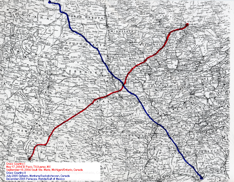 | |||
| [ HOME ] email © Gus Foster | |||